CLIMB EVERY MOUNTIAN!

Great hikes around The High South

Your High South Adventure must include our Hiking Trails! The Cashiers - Highlands - Western North Carolina area boast some of the most picturesque hiking trails in the United States. The first three hikes are the most popular and relatively easy.

The Top Hiking Trails in
The High South!

This is a list of some of the trails in Western North Carolina, including the Cashiers – Highlands area. The views and scenery from these hiking trails and mountaintops are spectacular! Escape from the city and enjoy the beautiful Blue Ridge and Smoky Mountains. Within very short drive from the crossroads in Cashiers NC or downtown Highlands NC, you can be at any number of trail heads or crossing points.
For the first time visitor, these are must do!

Whiteside Mountain

The trail takes you on a hike to 4,940 ft. elev. along the eastern Continental Divide, which offers spectacular views from a high ridge top, 2,100' above the valley floor. Whiteside Mt. has the highest sheer cliffs in the Eastern US.
Length: 2 mi. loop.
Rating:Easy to moderate
Trail Head:
Whiteside Mt. parking area.

Directions to Whiteside Mountain

From the intersection of N.C. 107 and U.S. 64 in Cashiers, drive west on U.S. 64 in the direction of Highlands. After 4.7 mi. on U.S. 64, turn left on Whiteside Mountain Rd. (SR 1690) at brown "Whiteside Mountain Trail" sign. Continue 1.1 mi., passing Wildcat Cliffs Country Club on right. Turn left into gravel parking lot. Click here for images!

Hiking Tips:

 -Do not hike alone
-Have a charged cell phone with you
-Watch your footing, there can be roots and loose rocks on the trails
-Allow more time than you think!
-Have Fun!

glen falls hiking

Glen Falls Hike

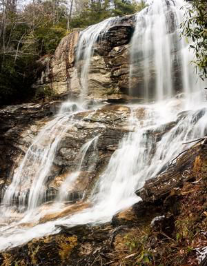
This trail takes the hiker through a pleasant forest of hardwoods and pines to one of the spectacular waterfalls of the Blue Ridge Escarpment. As Overflow Creek plunges over the ledge below one of the East's highest towns, you really get two falls in one. It forms two distinct tiers of falls totaling over 200' in height, each with an entirely different look and feel. Makes for an excellent half-day hike, and it's a great trail for familes and older children.
Length: 1.1 mile
Rating: More difficult
Trail head:
Glen Falls Parking Area

Directions to Glen Falls

From the corner of Main Street and NC 106 in Highlands, follow NC 106 West for 1.6 miles. Turn left at the sign for the Glen Falls Scenic Area, then IMMEDIATELY right onto the gravel road. The road crosses a bridge and ends after 1 mile in a small cul-de-sac. Park here.

DuPont
State Park

With over 80 miles of hiking trails, DuPont State Park also has several waterfalls that must be seen! Used as a film site during the blockbuster Hunger Games Movie, DuPont State Park is a must visit whether for an hour or a day!

Directions to DuPont State Park

From Cashiers, NC, travel east to Brevard, NC on highway 64. In downtown Brevard, take US 276 south to Cedar Mountain and turn left on Cascade Lake Road. Continue on Cascade Lake road for 2.5 miles, then turn right on Staton Road. Continue on Staton Road for 1.5 miles until you reach the High Falls Access Area. You can reach DuPont State Park from Cashiers in about 45 minutes.

PLAN YOUR TRIP!
DuPont State Park is so large and with many hiking options, please plan ahead! Visit the NC Forest Service web site and get started! https://www.dupontstaterecreationalforest.com/Default.aspx

Bartram Trail

West Fork, Bartram Trail

One of North Carolina’s long-distance trails and one of the state’s great hiking treasures. The trail stretches 100 miles starting in South Carolina, passing into Georgia, and ending in the Nantahala National Forest of North Carolina.There's plenty of terrific day hikes along the trail, one popular in the Cashiers-Highlands area is the:
Bartram Overflow Creek Loop
Length: 3.5 mile loop
Rating: More difficult
Trail head:
The Osage Overlook

Directions to Osage Mountain Overlook for the Bartram Trail Loop

From Cashiers, NC - Take Hwy 64 W to and thru downtown Highlands and turn left onto Hwy 106 toward Dillard, GA (Dillard Rd.) to Osage Overlook - about 4 miles from Highlands (address: 4594 Dillard Hwy, Highlands, NC).

More High South Hikes

Sunset Rock - Highlands

This is an ideal short ½ mile walk, perfect for really a “stroll” in the Highlands area. The trail leads to a natural cliff side amphitheater and absolutely beautiful sunsets.
Length: .06 miles (round trip).
Rating: Easy
Trail head:
Horse Cove Rd., across from the Highlands Nature Center.
Directions from Cashiers:
Take Highway 64 west to Highlands - at the light on Main Street turn left. Travel 1/2 mile to Nature Center on your left.

Whitewater Falls

Whitewater Falls, also called Upper Falls, is one of the highest falls east of the Rockies at 411 feet. This waterfall is designated a North Carolina Natural Heritage Area and it is accessible via a short 0.2 paved path off NC 281. The Foothills Trail passes near the Upper Whitewater Falls and this route is a loop hike that combines the Foothills Trail with a spur trail that crosses NC 281 near the Whitewater River bridge. There is a designated campsite along the spur trail, and a few other sites that are suitable for small groups that are looking for a nice overnight loop hike in this area.
Length: 5.1 Miles
Rating: Moderate
TRAILS USED: Foothills, Spur Trail
Trail Head: NC 281
Directions: From Cashiers North Carolina, drive south on NC and SC 107 9.3 miles to SC 413 and a sign for Whitewater Falls. Turn left and continue 2.3 miles to the intersection with SC 130. Hake another left and drive north on SC 130, which becomes NC 281 at the state line. Just beyond the state line is a sign for Whitewater Falls. Visitors coming from Toxaway and other points east should start at US 64 and 281 and drive south 8.6 miles to the Whitewater Falls parking area. New toilets are near the parking area.

© Copyright 2008 - [JS_CODE_0] High South Ventures, LLC

High South Adventures is part of The High South Media Network! Our other sites:

SapphireValleyResort.com
SkiSapphireValley.com
HighSouthRentals.com

All information believed accurate but not guaranteed. The High South Media Network covers news, events, vacation rentals and recreational opportunities all around the Blue Ridge and Smoky Mountains.